Climate change vulnerability and adaptation in Uganda’s cattle corridor
By Daniel McGahey and Zoe Visser
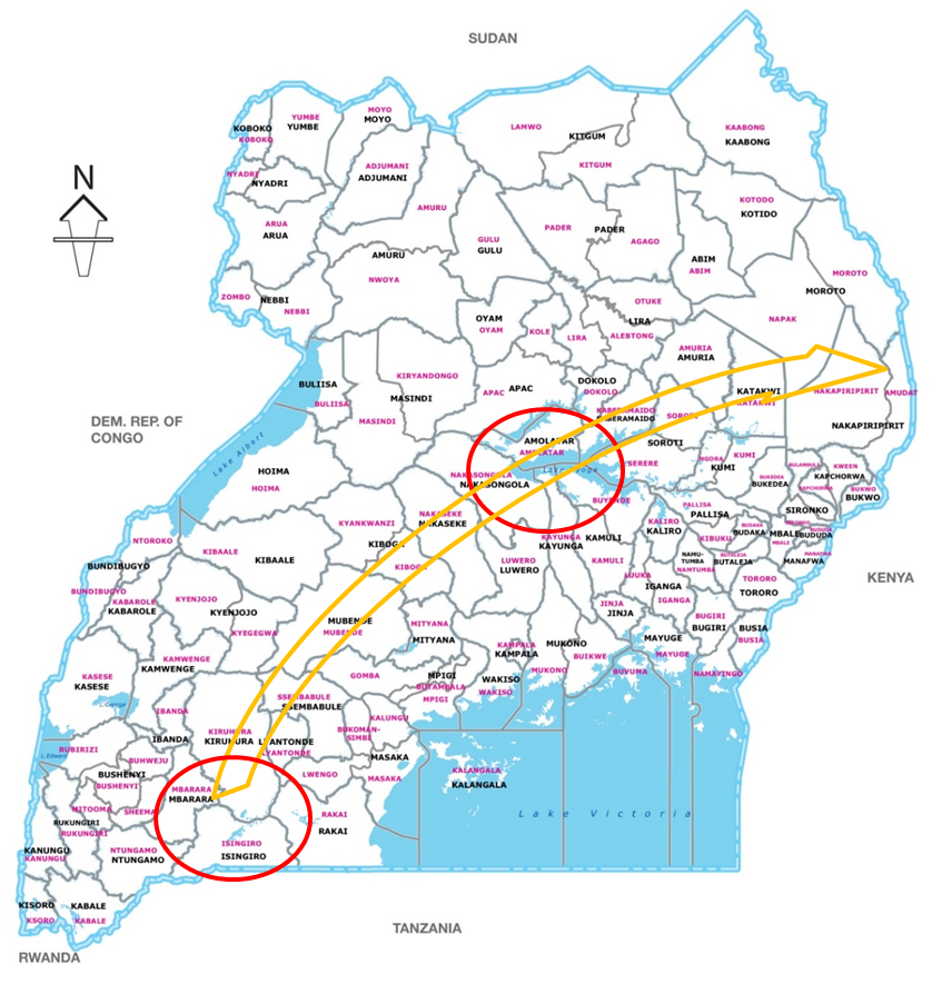
Uganda’s cattle corridor is a broad zone stretching from southwestern to northeastern Uganda, dominated by pastoral rangelands. While it is not currently classified as semi-arid, this corridor has many semi-arid characteristics. These include: i) high rainfall variability; ii) periodic late onset rains/droughts; and iii) historical reliance on mobile pastoralism as an important strategy to cope with resource variability. Given the cattle corridor’s vulnerability to climate change, and its importance for national and local food security, in February 2015 members of ASSAR’s East African team investigated the viability of using two corridor areas as sites for their regional research. The first area was Lake Mburo (situated across the Kiruhura District/Mbarara Districts), and the second the Nakasongola District (see map).

Districts of Uganda with sites visited highlighted and orange arrow showing approximate area of the Uganda cattle corridor
Over a five day period the team interviewed multiple stakeholders in these potential study areas, including landowners, farmers, community members, district administration, local government, private sector investors, and NGOs and other development actors. Local participants were interviewed on topics such as their observations of current climate hazards/stressors, their current coping strategies, and their levels of vulnerability. Development actors were interviewed about adaptation strategies and programmes, as well as their perceptions of important knowledge gaps and local research demands around climate change adaptation.

Important findings on climate-related vulnerability of both sites:
Livestock production: In both sites, livestock production is the dominant livelihood activity. Formerly open rangelands – which are under extensive pastoralism – have increasingly been allocated to land owners on an individual household basis. Despite this privatisation, livestock mobility is still used as a coping strategy during periods of severe water stress. During these periods, rainwater catchment dams dry up and households are forced to: i) pay high prices to truck water bowsers to their properties; ii) pay rental to access underutilised ranches; or iii) trek cattle to public water sources such as freshwater lakes. The latter activity often brings cattle owners into conflict with agriculturalists and other land owners.
Crop production: In both sites a variety of crops are grown on small areas of cultivated land. The main staple crops are maize, groundnuts, sweet potatoes, and cassava. In the Lake Mburo area, stronger cultural ties to the Bahima pastoralist livelihood system appeared to exist – although cultivation has increased, crop farming appeared of less importance to livestock production. Around Lake Mburo, in recent years several land owners have begun growing varieties of banana or plantain. In Nakasongola farmers have orchards where they grow cash crops of citrus fruits, mangos and avocado. Increasing temperatures and less reliable rainfall in the future could put these mixed farming systems under pressure. Farmers in Nakasongola District have already experienced an increase loss of orchard trees which they attribute to declining soil moisture.
Large-scale industrial development: Industrial development in the Kiruhura and Mbarara Districts has intensified existing water-scarcity issues. In 2012 a large scale dairy was established close to Lake Mburo to process dried dairy products for the export market. Initial attempts to drill boreholes at the site to provide the necessary water required to run the dairy were unsuccessful. The Uganda National Water and Sewerage Corporation have since established a pipeline that links the dairy to processed water drawn from Lake Kachera, but did not take cognisance of the fact that water levels were reduced to 25% of normal levels during the 1999 droughts. Due to insufficient water and supply of local milk, the dairy is currently running at well below capacity. Closer to Mbarara town there is a Coca Cola processing factory as well as a production plant for Nile Breweries. These industries also extract water from the main river feeding Lake Mburo and Lake Kachera.
Current adaptation initiatives in potential sites
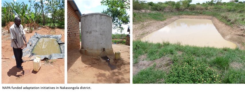
In both sites the most vulnerable households appeared to be landless labourers, or households with only small land holdings and limited rainwater catchment investment (i.e. household roof tanks or valley dams/tanks). Adaptation interventions around the Lake Mburo site are limited to district-level training and awareness-raising on climate change and adaptation, funded through the National Adaptation Programmes of Action (NAPA). In the Nakasongola site, a NAPA pilot project has been conducted under a Danish-funded project. Researchers visited communities benefiting from the initiative and were shown their household rainwater harvesting tanks, field based water catchment ponds and a community valley tank constructed under the NAPA programme.

Stakeholders appeared very interested in the ASSAR research objectives and were concerned about the impact of existing climate stressors on current livelihoods and resource availability in the cattle corridor. As was the case in northern Kenya, there were varying perceptions on the key knowledge gaps. As the ASSAR team has decided to use this area as a secondary site in their regional work, they will need to fully articulate the research objectives and scope to ensure realistic stakeholder expectations.
References
Allison, E. H., Perry, A. L., Badjeck, M.-C., Neil Adger, W., Brown, K., Conway, D., Halls, A. S., Pilling, G. M., Reynolds, J. D., Andrew, N. L. and Dulvy, N. K. (2009), Vulnerability of national economies to the impacts of climate change on fisheries. Fish and Fisheries, 10: 173–196.